Airport runway names shift with magnetic field
CGP Grey did a couple of episodes on runways[0] and airport codes[1] that are just fascinating and worth the watch
Interesting fact: the magnetic variation in Canada changes at a more frequent rate, and some northern airports got tired of updating their runway numbers every year or two so they now use true instead of magnetic headings (I believe indicated on the runway numbers like 17T to indicate true instead of 17 which would indicate magnetic).
Magnetic north moves in a fairly predictable way.
If you are in the UK you might be interested in Standup Maths’ video https://youtu.be/HcFvegnQpPo.
Currently true north and magnetic north are broadly the same in the UK - and over the next year or so, there is a point where grid north (Ordnance Survey maps) also coincides with both other “norths”. That point will track north over the UK.
The video shows Matt visiting Cornwall at a place where that point was.
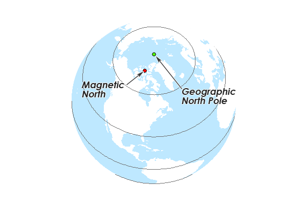
This is only one half of what actually happens while navigating; you have true north and magnetic north - see https://theprepared.com/wp-content/uploads/2017/08/Magnetic-... to visualise.
The difference between them depends on where you are on the globe - it could even be 180 if you happen to stand in the middle of the two!
Magnetic compasses always point to magnetic north, but with earth being molten metals - magnetic north likes to move around a bit, so we work out the difference between the two and apply it to the directions we track.
For example, where I am - the difference is around 11 degrees. In order to head directly west, I can't just let my compass point north and go directly perpendicular port - I have to point north plus 11 degrees, and then go. My actual track will be 281 degrees magnetic, not 270.
What's more interesting is that most navigation charts have all their directions and bearings in "true" north, with the variance also charted, whereas when you actually fly you track the magnetic headings plus/minus the variance. If you go long enough - the variance also changes so you have to take that into account when planning your route.
When you take off / land, runway headings directly corresponding to your heading are a good sanity check - alarm bells go off if you're meant to be flying west but come across Runway 09 in front of you (the opposite!), not to mention we still rely on magnetic compasses - you don't want to be coming into land at a track for 281 degrees and see 27 painted on it; chances are something went wrong somewhere.
Why is it desirable to correlate runway names with the Earth's magnetic fields? Is it because the navigational equipment breaks / becomes inaccurate when there's a field shift?
It seems like it could be confusing over time to keep updating runway names as flight paths are repeatedly flown by generally the same sets of pilots, and as paths becomes familiar. For fancy autopilot setups most of the in-the-moment thinking is avoided and this may become a very minor detail.
Edit: Thanks for the quick info everyone! Now this makes sense. Happy holidays :)
There was an interesting event a few y̶e̶a̶r̶s̶ months ago around Long Island, where it appeared that the Air Traffic Control software got confused by the magnetic declination. Basically it was generating false radar targets in the wrong place: They were rotated 13 degrees, the magnetic declination in the area, from the actual aircraft.
Thread with details here: https://twitter.com/lemonodor/status/1508505542423064578
A short summary is that sometimes when ATC radars see an aircraft, if it doesn't seem to have ADS-B (is in a position where no known ADS-B-equipped aircraft is), it will create a synthetic target, broadcasting it out so that aircraft with ADS-B In can see it on their traffic displays. That system is called TIS-B. Somehow the radar in Islip got confused by the magnetic declination: it was generating TIS-B targets that were rotated 13 degrees from where the aircraft really were. And it was doing it for pretty much every aircraft, whether or not it had ADS-B. I assume it wasn't able to correlate the known ADS-B position with the secondary radar returns because they were offset by 13 degrees.
Very weird way for a pretty important piece of ATC infrastructure to fail.
Simple question: is magnetic north actually a "north" or "south" pole? Which part of a magnetic compass is attracted to it?
FWIW, there was a discussion a year ago on HN about the aviation industry converting from magnetic to true:
"Why aviation’s compass is shifting towards True navigation"
https://news.ycombinator.com/item?id=28985745
Summary: "The debate about changing from Magnetic to True navigation is now moving towards how to change, and when, with March 2030 as the proposed date."
Since everyone is talking about how there are 2 north poles (geographic and magnetic), I'll add onto that that we have a 3rd north pole, the geomagnetic: https://www.earthdate.org/episodes/triple-north-pole
It does seem archaic that true north isn't used.
This NavCanada presentation - gives a good overview of the issues in changing.
https://www.navcanada.ca/en/magnetic-north-vs-true-north.pdf
This happened here in Tampa (TPA) just a few years ago. They shut down the runways to rename them from 18 to 19 to account for the magnetic shift. Must be a lot of repainting, it took a few days.
Wow I never would have guessed they use the magnetic compass for those 18L etc. markers. I guess that is to match up with the plane’s instruments.
I always wondered how sure they were that the core was iron and nickel, they say it so confidently like we just know.
I got criticized for not just hard coding the runway names in a billing app. I said don't y'all know these are the end times and we are at the early stages of a pole shift. I had the last laugh a few years later when the runways changed.